An AIS gap is a period during which a vessel that normally transmits stops appearing in the AIS record and later resumes. Because the AIS baseline is the reported picture of who is where, a gap is a hole in that picture, and holes are informative. A vessel that wants to conceal an activity often creates one. The analytical challenge is that not every gap is deliberate. This guide covers how to identify gaps in the baseline and investigate what they mean.
Step 1: Define what counts as a gap
The first task is establishing a baseline rhythm. A vessel’s normal reporting cadence depends on its equipment, its route, and the coverage in the area it transits. A gap is a deviation from that expected rhythm: a silence longer than the vessel’s own pattern would predict. Setting the threshold well matters, because too loose a definition floods the analyst with noise and too strict a one hides real concealment.
Step 2: Separate benign gaps from suspicious ones
Many gaps have innocent explanations. Reception is uneven, receivers have limited range, equipment fails, and dense traffic can cause message collisions. Before treating a gap as intentional, the analyst weighs several factors:
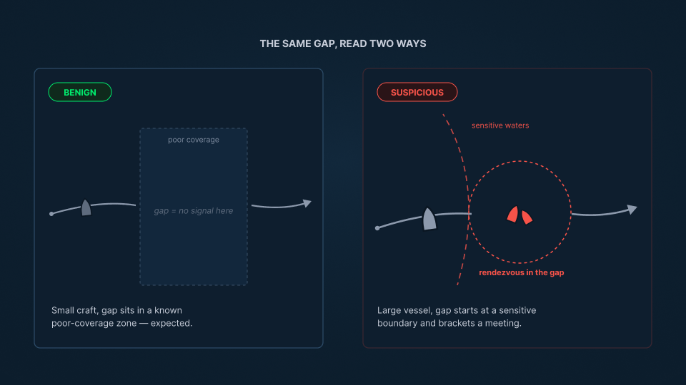
- Location: does the gap fall in an area with genuinely poor coverage, or in well-observed water where silence is unusual?
- Timing: does the gap begin and end at points that align with sensitive waters, a boundary crossing, or a possible rendezvous?
- Pattern: is this an isolated lapse, or one of a repeated series for the same vessel?
- Vessel: is this a small craft for which sparse reporting is normal, or a large commercial vessel whose silence is harder to explain?
A gap well explained by geography or vessel type is weak evidence. A gap that coincides with an opportunity for concealment, on a vessel that should be reporting, is worth pursuing. (See: What Is AIS Spoofing.)
Step 3: Fill the gap with imagery
A suspicious gap defines a window of time and an area of possibility. Imagery of the water is then used to find the vessel within that window, since it reveals a hull whether or not the vessel is transmitting. Where conditions require it, radar imaging and radio frequency detection extend that reach. Observations that fall inside the gap, in the reachable area, place the vessel during its silence and convert the gap from an unknown into a reconstructed segment of the voyage. (See: How to Track Vessels Without AIS and How to Detect Dark Ships.)
Step 4: Interpret the behavior around the gap
The final step is meaning. A reconstructed gap is examined alongside what the vessel did immediately before and after it. A gap that brackets a mid-ocean rendezvous, a course into restricted waters, or a change in draft that suggests loading or discharge is not merely a data lapse. It is a period the vessel had reason to hide, and it feeds a broader assessment. The gap itself is never the conclusion; the behavior it conceals, weighed in context, is. This reasoning is central to maritime domain awareness. (See: What Is Maritime Domain Awareness.)
From silence to sequence
A gap is only a mystery until it is investigated, and only worth investigating once context says it might matter. SynMax delivers the capability to do both through Theia, reading gaps against the reported baseline, filling them with imagery, and applying the judgment that tells a routine lapse from a concealed event.
That is the standard we hold to across everything we build: Ground Truth for Every Decision.
If your team needs to investigate the gaps in a vessel’s track, request a demo and we will show you what that looks like in your area of interest.