AIS is the base layer of vessel tracking, and for the cooperative majority of traffic it is accurate and sufficient. The challenge is that AIS is voluntary. A vessel can operate without transmitting, or transmit a position that is not true, and the reported picture no longer matches reality. Tracking a vessel in that situation does not mean discarding AIS. It means using the AIS baseline to know what should be on the water, enriching it with imagery to see what actually is, and applying judgment to decide which of the differences matter. This guide walks through that workflow.
Step 1: Start from the AIS baseline
The reported picture is the reference frame, not the enemy. It tells you which vessels are declaring themselves, where, and doing what. That baseline is what makes everything else meaningful, because it defines what is accounted for. A hull is only worth calling unaccounted for once you know what the baseline already explains. Beginning here also keeps the workload sane, since the cooperative majority needs no further investigation.
Step 2: Enrich the baseline with imagery
Enrichment comes from observing the same water directly. Imagery shows what is physically present, independent of what any vessel chooses to broadcast, and it is sufficient for the great majority of the work. Where conditions demand it, particular imaging types add strengths: radar imaging holds up through cloud and darkness, optical adds visual detail in clear daylight, and radio frequency detection registers emitted signals. The purpose of all of them is the same, to establish ground truth about what is on the water. (See: How Satellite Vessel Detection Works and What Is RF Detection in Maritime Surveillance.)
Step 3: Correlate to find the candidates
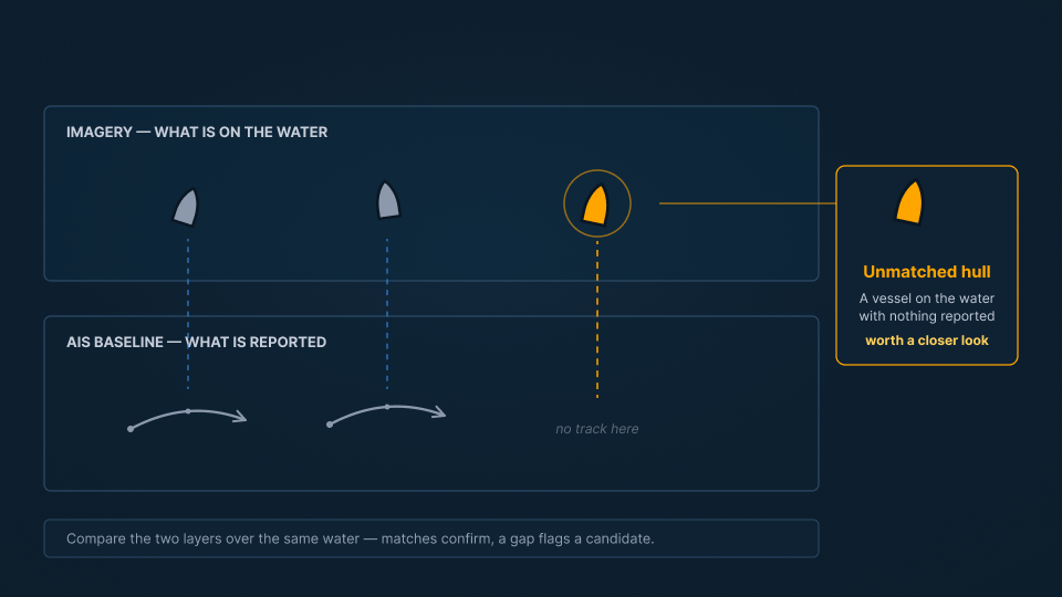
With both layers in hand, the interesting cases are where they diverge. An observed hull that matches an AIS track is a confirmed vessel. An AIS track with no hull where it claims to be points to a falsified position. An observed hull with no AIS to account for it is a candidate for closer attention. Correlation across successive observations then links detections into a continuous track, so a candidate can be followed rather than glimpsed once.
Step 4: Judge which candidates matter
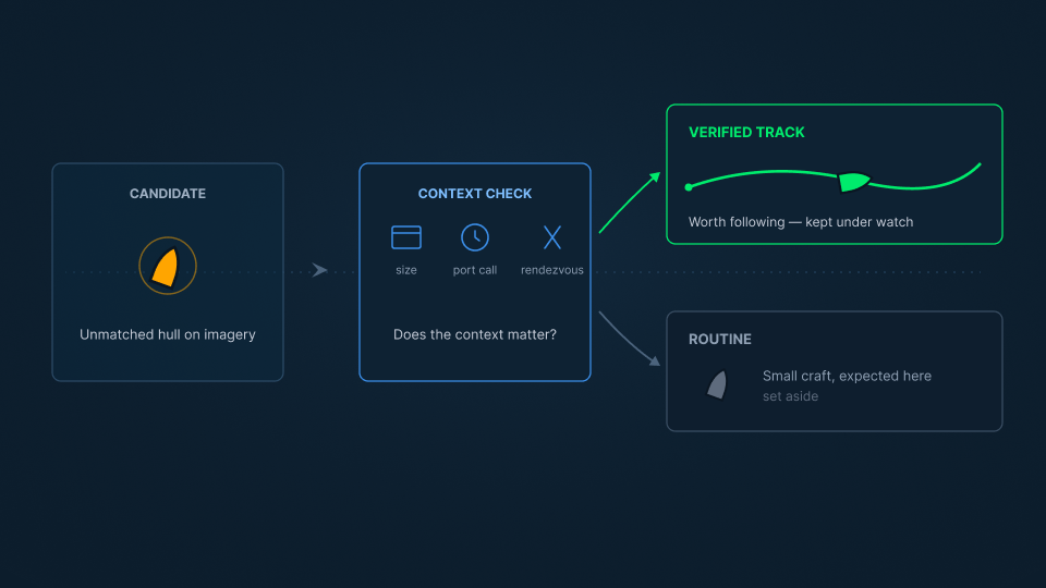
A hull with no matching AIS is a candidate, not a conclusion. AIS is voluntary, so absence of it is not by itself a signal. A ten-metre pleasure craft with no transponder is almost certainly nothing. A fifty-metre cargo vessel with no transponder that recently called at a sanctioned port, or that held a rendezvous at sea, is worth close attention. The observation can look the same in both cases; the significance comes from the vessel class, its history, and the context around it. This judgment is what turns tracking into intelligence rather than a longer list of contacts. (See: What Is Maritime Domain Awareness.)
Step 5: Attribute and maintain the picture
For the candidates that matter, the next step is establishing which vessel it is. Physical measurements from imagery are matched against vessel records to resolve identity, turning an anonymous contact into a named vessel with a history. Because these vessels can go quiet, change behavior, or reappear under a different identity, persistent observation keeps the picture current so the vessel remains accounted for over time. (See: How to Detect Dark Ships.)
From absence to answer
A vessel that stops reporting has not stopped existing, but not every silent vessel is worth chasing. SynMax delivers the capability to tell them apart through Theia, anchoring on the AIS baseline, enriching it with imagery, and applying the judgment that identifies which unaccounted hulls actually warrant attention.
That is the standard we hold to across everything we build: Ground Truth for Every Decision.
If your team needs to track the vessels that will not track themselves, request a demo and we will show you what that looks like in your area of interest.